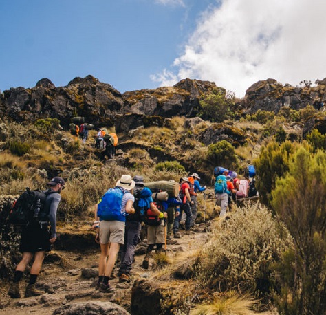
Nach einem frühen Frühstück erhalten Sie eine Einweisung von Ihrem Guide. Um 9:00 Uhr nehmen Sie unsere Mitarbeiter mit auf die einstündige Fahrt von Ihrem Hotel in Moshi zum Dorf Umbwe, wo Ihre Guides und Träger Ihre Ausrüstung und Vorräte vorbereiten. Hier wird die Anmeldung zum Kilimanjaro Park abgeschlossen und Sie erhalten auch Ihr Lunchpaket. Nach der Registrierung beginnen Sie Ihren Aufstieg vom Umbwe Gate und fahren auf einem kleinen Fahrzeugweg weiter, bis Sie die Beschilderung erreichen, die Sie über den Umbwe Trail informiert. Sie werden dann 5-6 Stunden durch dichten Regenwald klettern. Die riesigen Feigen- und Gummibäume sind nicht zu übersehen, da an manchen Stellen ihre Wurzeln den Weg überholt haben. Obwohl sie manchmal selbst rutschig sind, können sie einen guten Halt bieten, wenn der Weg nach einem Regen schlammig wird. Das Umbwe Camp liegt im Wald und ist Ihr erster Halt. Bei Ihrer Ankunft finden Sie Ihr Lager und Zelt bereits von den vorauslaufenden Trägern aufgebaut. Sie bringen Ihnen abgekochtes Trinkwasser und Waschwasser als Vorbereitung für das Abendessen.
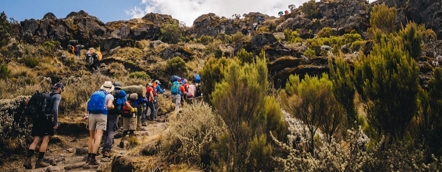
Stehen Sie früh auf, um Kaffee oder Tee zu trinken. Nach dem Frühstück packen Sie für die Tageswanderung ein. Ihre Wanderung beginnt steil durch die verschwindenden Regenwaldlichtungen, bevor Sie in die trockenere Luft des Giant Erica- und Heat hland-Geländes aufsteigen, wo die Vegetation spärlich mit kleinen Sträuchern ist. Weiter geht es auf einem ausgesetzten Grat, der dir deinen ersten Blick auf den Uhuru Peak bietet, wenn sich die Wolken genug geteilt haben. Nach dem Mittagessen betreten Sie das Gelände der Halbwüste, wenn Sie durch einen Garten mit Senecio-Pflanzen wandern. Diese seltsam aussehenden Groundsel ähneln so etwas wie einem prähistorischen Kaktus. Sobald Sie das Barranco Camp erreichen, kochen Ihre Träger Trink- und Waschwasser, bevor sie das Abendessen servieren. Während Sie auf Ihr Abendessen warten, haben Sie die Möglichkeit, einen der unvergesslichsten Sonnenuntergänge zu erleben, die Sie je gesehen haben, während die Sonne über dem Tal versinkt. Achten Sie auf Ihren Körper und informieren Sie Ihren Guide über alle Anzeichen der Höhenkrankheit
Tag 3 verbringen Sie in der Nähe des Barranco Camps für die dringend benötigte Akklimatisierung. Halten Sie Ihre Kamera griffbereit, um die Landschaft des mit Streuseln bedeckten Campingplatzes einzufangen. Viele Trekker bezeichnen dies als ihr Lieblingscamp auf diesem Weg, was ein weiterer Grund dafür ist, dass dies der perfekte Ort für Ihren Akklimatisierungstag ist. Wenn Sie sich sehr sicher sind, dass sich Ihr Körper gut akklimatisieren kann, können Sie die 6-tägige Umbwe-Route wählen.
Nachdem Sie unterhalb der Great Barranco Wall geschlafen haben, haben Sie Ihre Chance, diese Hürde zu nehmen. Keine Sorge ... Es ist viel einfacher als es aussieht. Weiter hinauf bis knapp unterhalb des Heimgletschers. Dann geht es hinunter durch das Karanga-Tal. Dies ist der letzte Ort für Ihre Träger, um Wasser zu sammeln. Sie sammeln hier das gesamte Wasser für den Rest des Aufstiegs. Sie werden sich hier im Karanga Camp einleben. Nach dem Mittagessen können Sie den Nachmittag damit verbringen, leichte Erkundungen zu unternehmen oder sich auszuruhen, während Sie die Aussicht auf die hoch aufragenden Türme von Mawenzi genießen
Nach dem Frühstück fahren Sie nach Osten, überqueren mehrere Kämme und Täler, bis Sie auf die Mweka-Route treffen und nach links abbiegen, um eine Stunde lang den Kamm hinaufzusteigen, um die Barafu-Hütte zu erreichen. Sie erreichen das Camp und finden Ihr Zelt auf einem felsigen Bergrücken mit starkem Wind auf. Machen Sie sich vor Einbruch der Dunkelheit mit dem Camp vertraut, um sicher zu gehen. Halten Sie außerdem Ihre Stirn-/Taschenlampe bereit, wenn Sie das Zelt nach Einbruch der Dunkelheit verlassen müssen. Sie bereiten Ihre Ausrüstung (Batterien für Stirnlampe und Kamera ersetzen) vor dem Schlafengehen bis 19:00 Uhr vor und versuchen, vor Ihrem Gipfelversuch ein paar Stunden die Augen zu schließen
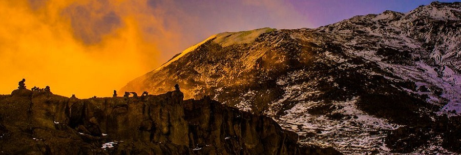
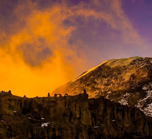
Wachen Sie um 23:30 Uhr mit Tee oder Kaffee und Keksen auf und verlassen Sie dann Barafu auf Ihren Wunsch zum Gipfel. Sie klettern 6 Stunden durch dickes Geröll und folgen mehreren Serpentinen zwischen dem Ratzel- und Rebmanngletscher bis zum Stella Point (18.650 ft/5.685 m). Sie haben gerade den für die meisten Kletterer anspruchsvollsten Teil ihrer Wanderung hinter sich gebracht. Abhängig von Ihrem Tempo bis zu diesem Punkt haben Sie möglicherweise die Möglichkeit, während Ihrer kurzen Rast hier den majestätischen Sonnenaufgang zu genießen. Obwohl Sie müde werden, ist es aufgrund der extremen Kälte wichtig, in Bewegung zu bleiben. Am Stella Point haben Sie das letzte Stück der Marangu-Route erreicht. Sie wandern weitere 1-2 Stunden am Rand entlang, bis Sie Ihr ultimatives Ziel, den Uhuru Peak, erreichen. Herzlichen Glückwunsch, Sie stehen jetzt auf dem Dach Afrikas! Sie haben Zeit, Fotos mit dem weltberühmten Uhuru-Peak-Schild zu machen, aber es ist wichtig, bald mit dem Abstieg zu beginnen, um sich im Barafu Camp genügend Zeit zum Ausruhen zu gönnen. Nach einer 3-stündigen Abfahrt über rutschende Geröllhalden erreichen Sie Barafu, um eine kurze Rast einzulegen, während Sie Ihre Ausrüstung sammeln und dann den Weg hinunter in das Waldlager von Mweka fortsetzen. Am Nachmittag kann es ein wenig regnen, also denken Sie daran, Ihre Regenbekleidung in Ihrem Tagesrucksack zu haben. Genießen Sie ein Abendessen und einen wohlverdienten Schlaf. Im Mweka Camp verkauft das Büro Mineralwasser, Erfrischungsgetränke, Schokoriegel und Bier
Wachen Sie wie gewohnt zum Frühstück auf, packen Sie und steigen Sie durch eine kurze, landschaftlich reizvolle 3-stündige Wanderung zum Mweka Gate ab. Warten Sie, bis Sie und Ihre gesamte Ausrüstung das Gate erreicht haben, bevor Sie Ihrem Personal Trinkgeld geben. Nachdem Sie sich am Gate registriert haben, warten Sie auf Ihre Gipfelurkunden (grün für diejenigen, die den Stella Point erreicht haben und gold für diejenigen, die den Uhuru Peak erreichen). Wenn die Straße für Fahrzeuge zu schlammig ist, wandern Sie vom Tor aus für 1 Stunde zum 3 km entfernten Dorf Mweka. Dort genießen Sie ein warmes Mittagessen, bevor Sie zurück nach Moshi fahren, wo Sie Ihre erste heiße Dusche seit Tagen nehmen können
Abreisetag: Transfer zum Flughafen Kilimanjaro
During the climb your accommodation will be camping.
This route takes 6 days to complete the climb although 7 days is recommended as Umbwe is the most difficult route of all. Ideally this route is for those who are up for a challenge and are physically fit due to the of steepness of the route. It is also the least crowded route.
With reference to the quote, we shall be providing you with all your camping equipment, along with tents and sleeping mats. What are not included are sleeping bags (although these can be hired), water canteens, flashlights and clothing. Provided below is a list of suggestions.
Prior to departure, you will need to pack the bulk of your clothing and gear into a large rucksack or duffel bag which will be carried by the crew. Note, no bag on Kilimanjaro (irrespective of who carries it) should weigh more than 15 kg and will be weighed at the gate). Clients will carry a smaller backpack or day-pack with key items of clothing and personal effects.
After a hearty breakfast your guide will come to collect you from Honey Badger Lodge and you will drive to Umbwe gate. After completing the gate registration procedures, the trek starts through the rainforest. There is a strong possibility of rain in the forest, which will transform the trail into a very soggy, muddy and slippery experience. You will have a welcome packed lunch stop about half way and you will continue walking until you reach Umbwe cave camp area in the late afternoon. The crew will set everything out at your campsite and all you have to do is sit back, relax and enjoy the great outdoors.
On Day two the landscape changes rapidly from rainforest to moorland, with rocky outcrops and sparse vegetation. The path follows the narrow Umbwe Route ridge until it begins to flatten close to the Barranco Valley. The Barranco Camp (3,950 m) sits in the valley under the shadow of the Great Barranco wall with Kibo visible in the distance. You will notice the camp is pretty busy. This is because you will be joining hikers from the Machame, Lemosho and Shira Route. When reaching the camp the crew will provide you with a tasty meal and you will then have plenty of time to sit back and relax.
Today you will be having a short day walk and in the late morning you will start climbing Barranco wall and reach 4,200 m for acclimatisation and continue crossing ridges and valleys to Karanga Campsite for hot lunch. After a delicious lunch you will have a short rest and another acclimatisation of trekking up the screed slopes toward the Southern ice field then you will return to the camp for dinner and overnight stay. On the way our experienced team will coach you through the symptoms and provide you with all the advice and support you need.
Your day begins by trek up to the Barafu ridge. It will be little tough because of the altitude. On this day the walking hours will be few because the path is steep hence needs slow walk in order to avoid fatigue as well as high altitude sickness. You will walk across the alpine desert with strong and cold wind blowing because there is no trees around as well as getting closer to the Kibo glaciers. On this day you will have an early dinner of around 17.00 h then try to get some precious rest and sleep until midnight when you push for the summit.
At about 23:30h you will be awoken to some tea and biscuits and will make a move into the night. You will head in a north-westerly direction and ascend through heavy scree towards Stella Point on the crater rim. Many climbers find this 6-hour walk to Stella point the most mentally and physically challenging aspect of the climb. At Stella Point (5,685 m) your efforts will be rewarded with a short rest and the most magnificent sunrise you are ever likely to see (weather permitting). From Stella Point you will normally encounter snow all the way on your 2-hour ascent to Uhuru Peak, the highest point in Africa and achievement you will remember for the rest of your life. The walk back to Barafu from the summit, takes about 3 hours. Here you will have a well-earned but short rest and collect the rest of your gear, before heading down to Mweka camp (3,100 m). The route is not difficult and will take you down the rock and scree path into the moorland and eventually into the forest. Here you will rest and feel proud of your achievement.
After an early and well-deserved breakfast, it is a short 3-hour and scenic hike back to the Park gate where you will receive your certificates; those climbers who reached Stella Point (5,685 m) are issued with green certificates and those who reached Uhuru Peak (5,895 m) receive gold certificates. You will be picked up and brought back to the lodge for a warm welcome, a cold celebratory drink and a hearty meal.
mount kilimanjaro from Nairobi Kenya, mount kilimanjaro from Kampara Uganda, mount kilimanjaro from Kigari Rwanda,
mount kilimanjaro gears, mount kilimanjaro camps, mount kilimanjaro records, mount kilimanjaro clothes, mount kilimanjaro base camp
mount kilimanjaro climbing companies, mount kilimanjaro informations, mount kilimanjaro vegetations and frowers
mount kilimanjaro hiking company, mount kilimanjaro hiking operator, mount kilimanjaro hiking operators,
mount kilimanjaro hiking agency, mount kilimanjaro hiking, mount kilimanjaro internet, mount kilimanjaro electricity
mount kilimanjaro hiking agences, mount kilimanjaro climbing adventures, mount kilimanjaro hiking adventure,
mount kilimanjaro hiking holiday, mount kilimanjaro hiking, mount kilimanjaro wanders, mount kilimanjaro to ngorongoro-crater
mount kilimanjaro hiking holidays, mount kilimanjaro hiking expeditions, mount kilimanjaro dangerous, mount kilimanjaro song
mount kilimanjaro ultimate, mount kilimanjaro ten interesting facts about, mount kilimanjaro Tanzania, mount kilimanjaro meaning
mount kilimanjaro the ultimate guide to Africa highest mountain, mount kilimanjaro formation, mount kilimanjaro travel
mount kilimanjaro hiking expedition, mount kilimanjaro climbing organizer, mount kilimanjaro local guide,
mount kilimanjaro acclimatizatiom, mount kilimanjaro creter, mount kilimanjaro national park tourism, mount kili
72 kilometres
Distance: The Rongai route is 72 kilometres (44 miles) long. Location: The Rongai route ascends Kilimanjaro from the northeastern side of the mountain, along the border between Tanzania and Kenya.
Northern Circuit Route
Northern Circuit Route has the highest Kilimanjaro Success Rate which is 95% and approaches from south of Kilimanjaro. It is the newest and longest route which offers the most spectacular view of overall 360-degree scenery of Mount Kilimanjaro. Climbing Mount Kilimanjaro on this route takes 8 to 9 days for the summit.
72 kilometres
Marangu route distance
Distance: The Marangu route is 72 kilometres (45 miles). Location: The route approaches Mount Kilimanjaro from the southeast. The trail itself starts at Marangu gate. Height: The route reaches the summit of Kilimanjaro at the Uhuru peak reaching a height of 5,895 metres (19,341 feet
approximately 62 kilometers The total Machame route distance is approximately 62 kilometers from gate to gate. One can complete the Machame route on a 6 or 7 day itinerary. Both options include a climb high, sleep low acclimatisation day.
The Machame Route: the most popular climbing route up Kilimanjaro. The Rongai Route: the easiest route on Kilimanjaro. The Shira Route: this one catapults you to some serious altitude on the first day. The Lemosho Route: hands down the most beautiful Kilimanjaro climb route, but expensive.
Climbing Kilimanjaro is probably one of the most dangerous things you will ever do. Every year, approximately 1,000 people are evacuated from the mountain, and approximately 10 deaths are reported. The actual number of deaths is believed to be two to three times higher.
The Machame Route is approximately 62 km/ 37 miles from gate to gate. It is designed for physically fit people with some hiking experience, but plenty of first time trekker use the route as well and do just fine. It is rated as one of Kilimanjaro's better routes and thus is recommended. 37 miles
We generally advise that the best time toclimb Kilimanjaro is during the warmest and driest times of year, from December to mid-March and mid-June to the end of October. However, although these are considered to be the best times to climb the mountain in terms of weather, they are also the busiest months.
Kilimanjaro is an achievement many hikers, athletes, and nature lovers have set their eyes on. But towering 19,341 feet, with a nearly 50% fail rate, reaching the peak takes a hefty amount of work against significant odds. Climbing Mt. Kilimanjaro is absolutely worth it.
How much does it cost to climb Kilimanjaro? the average trek price is $2000 to $4000 with many variables, read on for some prices. Climbing Mount Kilimanjaro is an expensive venture.
between 45% and 65%
Overall summit rates on Kilimanjaro (across all routes & climbers) are estimated to fall between 45% and 65%. Summit success rates by climbing duration - don't try to do Kilimanjaro on an itinerary that is shorter than a week or you'll set yourself up for failure.
Firstly, in our opinion, the summit day on Kilimanjaro is harder than anything you will encounter on the Everest Base Camp Trek. However, the days on Everest Base Camp treks are longer. Also, the day to day trekking is a bit tougher than on Kilimanjaro.
At the summit, Uhuru Point, the night time temperatures can range between 20 and -20 degrees Fahrenheit (-7 to -29 degrees Celsius). Due to Mount Kilimanjaro's great height, the mountain creates it's own weather.
Rongai route
The Rongai route is the easiest route up Kilimanjaro. It has a reputation as a remote wilderness trail. Rongai is the only route to approach Kilimanjaro from the north.
As we mentioned before, Kilimanjaro is suitable for beginners; they do very well. The best advice is for everyone to arrive in great shape. Don't underestimate the climb because you know someone did it who you believe was not fit. Train for the adventure.
You don't need to be exceptionally fit, but you do need to get your body used to the particular demands of this hike. Otherwise the first days will be so tiring that you will have no energy left when it counts. So, the best Kilimanjaro training is to simply walk.
Read our approach to summit night on Kilimanjaro is hard 1,245m/ 4,084ft of ascent at high into extreme altitude above 5,500m/ 18,000ft. It can take up to 7 hours to reach the summit. We like to set up camp in Kosovo Camp.
Ideally, you should try to hike as much as possible on hills or mountains to simulate climbing Mount Kilimanjaro. Doing day hikes is superb training. For those who do not have access to trails, the next best option is to train on stairs. You can also train very productively on a stair master machine.
Unfortunately it is not possible to climb Kilimanjaro without a guide. In 1991 the Tanzanian government and Kilimanjaro National Park Authority changed it's policy towards unsupported treks on Mount Kilimanjaro. In short the regulations require that all trekkers are accompanied by a registered and licensed guide.
257 m
How high is the Barranco Wall? The Barranco Wall Kilimanjaro is just 257 m from base to top. Many people think of it as being more than that
A detailed analysis of six cores retrieved from the rapidly shrinking ice fields atop Tanzania's Mount Kilimanjaro shows that those tropical glaciers began to form about 11,700 years ago. The cores also yielded remarkable evidence of three catastrophic droughts that plagued the tropics 8,300, 5,200 and 4,000 years ago
Have there been deaths on Mount Kilimanjaro? Approximately 30,000 people attempt to Climb Mount Kilimanjaro every year and on average the reported number of deaths is about 10 fatalities per year.
128,263 Steps Climbing Kilimanjaro, the Roof of Africa, in 128,263 Steps...
You do not need supplemental oxygen to climb Kilimanjaro. Supplementary oxygen is normally only used at extreme altitudes above 23,000 feet. Heights greater than 26,000 feet are inhospitable for sustained human life.
Snow on Kilimanjaro can occur all year round, but the most common months are November through March.
The 'Seven Summits' are comprised of the highest mountains on each of the seven continents of the Earth: Everest, Aconcagua, Denali, Kilimanjaro, Elbrus, Mount Vinson and Carstensz Pyramid.
Mount Kilimanjaro
Last eruption Between 150,000 and 200,000 years ago
Climbing
First ascent (European) 6 October 1889 by Hans Meyer and Ludwig Purtscheller
Easiest route Hiking
The short answer to the question: Can anyone climb Mount Kilimanjaro? is obviously no. ... You don't need to be particularly fit (indeed being too fit can be detrimental) and you do not need any technical climbing skills
The reason it is so expensive is because of the fees the government charges for you to climb the mountain. Mt. Kilimanjaro is a national park, and the Tanzanian government charges very high fees for you to visit it. ... The vast majority of the $1000 or so you have to pay goes to the government of Tanzania.
1. Acclimatise prior to the climb. ...
2. Start the climb in the best possible health and with an excellent level of physical fitness.
3. Take it easy on the trail and in camp. ... <
4. Drink plenty of fluids. ...
5. Eat well. ...
6. Sleep well. ...
7. Relax.
Most days climbing Kilimanjaro are no worse than an average day hiking at home. There are though a number of factors that make this a really tough challenge. First, you will be hiking for at least 7 days continuously. This puts a big strain on all your muscles and joints.
Stella Point is one of three summit points on Mount Kilimanjaro, next to Gilman's Point and the actual summit – Uhuru Peak.
Where do you sleep when you climb Kilimanjaro? When you trek Mt Kilimanjaro, you sleep in one of two places: in a mountain hut or a tent. Most trekkers sleep in tented camps, as only the Marangu route offers hut accommodation.
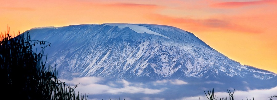
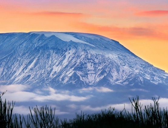
Mount Kilimanjaro is the tallest mountain on the African continent and the highest free-standing mountain in the world. ... Kilimanjaro has three volcanic cones, Mawenzi, Shira and Kibo. Mawenzi and Shira are extinct but Kibo, the highest peak, is dormant and could erupt again
The best route to climb Mount Kilimanjaro is the Lemosho Route. In our opinion the Lemosho route is the most scenic route on the mountain and the route that has the best acclimatization for a safe, enjoyable and successful ascent of Kilimanjaro.
16,732 feet Kilimanjaro lies within the 292-square-mile (756 square kilometers) Kilimanjaro National Park. Kilimanjaro rises from its base approximately 16,732 feet (5,100 meters) from the plains near the Tanzanian municipality of Moshi, making it the tallest free-standing mountain in the world.
You can drive up a section of Mt. Kilimanjaro but you can't get to the summit of the mountain using a vehicle. The closest you can get to the top of Kilimanjaro using a vehicle is by taking the Shira route which will drive you up the slopes of Kilimanjaro to 11,000 ft.The Rongai Route is the only route that appraoches Kilimanjaro from the north, near the Kenyan border. Rongai’s ascent profile is very similar to that of Marangu. It is one of Kilimanjaro’s easier routes. The climb to the top is gradual and steady. However, unlike Marangu, this route has low crowds and passes through remote wilderness areas. It is probably the only route where seeing wildlife in the first days is possible.
he route takes six days minimum to complete, although seven days is recommended. The descent is down Mweka, on the south-east side of the mountain. Because the starting point is far from Moshi, it is more expensive to climb this route due to the added transportation cost of getting climbers to the gate.
Scenically, Rongai is beautiful because it travels through an unspoiled rain forest and remote wilderness area. However, it is not as scenically varied as Machame, Lemosho and Shira.
Rongai is ideal for those who are not confident in their ability to hike over steeper paths, those who want to avoid traffic, and those who want to enjoy a quieter hike. It is also preferred when climbing during the rainy season because the north side of the mountain receives less precipitation.